

Esperance Region & Recherche Archipelago

Pristine Australian coastal wilderness, probably as good as it gets. Some of Australia’s most beautiful seascapes
A Nature Reserve, Recherche Archipelago (known by locals as The Bay of Isles) contains 105 pristine islands, and over 1,200 rocky outcrops (often only exposed at low tide), off the southern WA coast near Esperance. The islands stretch 230 kms from east to west. From the land, the archipelago provides a stunning seascape - turquoise water with islands scattered indiscriminately here and there. The islands are arranged in two groups - the western group (includes Woody Island, and is off-shore from Cape Le Grand National Park) near Esperance, and the eastern group (includes Middle Island, and is near Cape Arid National Park) at Israelite Bay.
The area became known to Europeans when Pieter Nuyts and Francois Thijssen, sailing in the Golden Seahorse (Gulden Zeepaert), visited the coast in 1627. The Archipelago of Recherche (Archipelago of Research) was actually named by Bruni d’Entrecasteaux during a French expedition in 1792 - his ships were the L’esperance and Recherche. Matthew Flinders was the first to explore and chart the islands and coastline in detail, as part of his 1802 circumnavigation of Australia.

THE NATURAL ENVIRONMENT
Most of the islands sit in 60 metres of water, washed by the warm easterly-flowing Leeuwin ocean current. In summer, this current can actually warm the cold seas to around 20-degrees. Generally composed of granite outcrops (particularly the smaller islets), these islands often have steep-sided slopes - a few are fringed with white sand beaches. Larger islands are vegetated, supporting animals and birdlife, including a significant number of plants and animals which are unique to the islands. There are two different sub-species of rock wallabies, plus bandicoots and tammar wallabies.
The archipelago is a designated ‘Important Bird Area’. This is the world’s only breeding site for the western sub-species of the Cape Barren goose, known as the Recherche Cape Barren goose. Over 1% of the world population of sooty oyster-catchers, fairy terns, and flesh-footed shearwaters are found here. There are also sea eagles, and occasional appearances by rock parrots and red-eared firetails.
Marine mammals associated with the islands feature two species of seal, large groups of dolphins, and (between July and October) migrating whales. Breeding colonies and haul-out sites of the Australian sea lion and NZ fur seal are found on many of the islands. Commercial fishing is primarily for abalone, Esperance rock lobster, pilchard and sharks. An aquaculture venture to breed bluefin tuna, is proposed.
TOP DIVING SITE
The clear turquoise waters have some quite extensive reefs, that create a natural habitat for rich marine-life diversity. There are hundreds of species of sponge, soft coral, and sea grass. Experienced divers can explore the granite walls, underwater caves, reefs, and a couple of wrecks. This includes the second largest accessible shipwreck dive-site in the world, the 174-metre Korean bulk-carrier Sanko Harvest which broke in two, and sank in 1991. The wreck (now a marine sanctuary) sits in 30-40 metres of water, 21 nautical miles off-shore - it’s well broken up these days, but into pretty big pieces. Dive exploration can include the bridge area, engine room and tower cranes. At the time, the Sanko Harvest leaked 700 tonnes of bunker oil and 30,000 tonnes of fertilizer, causing a major environmental problem.
ESPERANCE - HISTORIC PORT FOR THE GOLDFIELDS
Remote, and a bit of an ‘isolated gem’, Esperance (French for ‘hope’) rests on a quite remarkable piece of Australia’s southern coastline. Approximately 715 kms from Perth, it has a population of some 12,200. Currently Esperance is the only port in WA’s southeast, and one of the deepest in southern Australia. It’s capable of handling fully-loaded Panamax vessels. The town faces a scattering of islands belonging to the Recherche Archipelago, which provide superb viewing from the Taylor Street Quarters - a town dining precinct. In the 1800s, a mix of whalers, sealers, pastoralists and miners took advantage of a free-land deal to settle here and exploit the gold-mining boom (Coolgardie, Kalgoorlie) that was happening just to the north. A town jetty was built, and Esperance became the Gateway to the Goldfields. The early settlement also served as an important link in the overland telegraph line between Albany and Eucla. By 1927, a railway line linked the Coolgardie goldfields to Esperance. Large-scale grain and agricultural production was successful in the area, necessitating an even bigger second jetty.

Esperance Today
REMOTE BUT PERSONABLE TOWN

The Growers Market in Esperance is today a bit of a local institution. A personable experience, held fortnightly at the Scout Hall, the market offers local organic produce, pastries and snackgoodies, tea and coffee, preserves and flowers. Check out the hand-picked olives and oils from the local Yirri Grove olive farm. Town electricity is supplied by wind turbines. The first electrical wind farm in Australia was a research facility built at Salmon Beach (near Esperance) in 1987. On the way to Cape Le Grand (and just 15 minutes from town), there’s a bit of ancient druid history in a full-size replica (only one in the world) of UK’s Stonehenge. It was formed by using 137 slabs of Esperance pink granite, and is aligned with the summer and winter solstices in December and June respectively.

AROUND THE TOWN
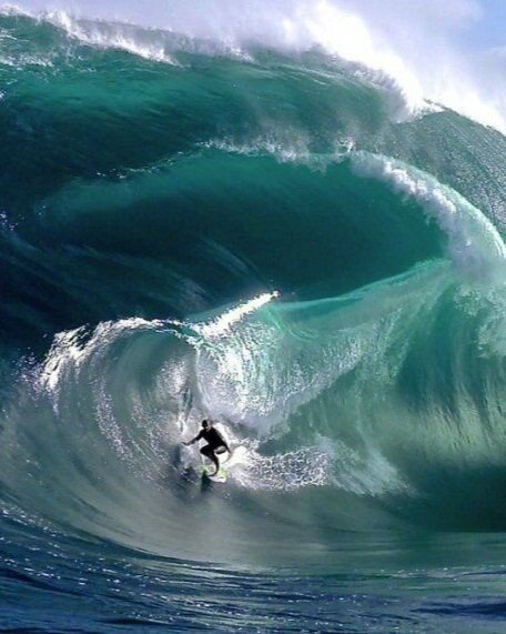
There’s a purpose-built 13-km scenic mountain-bike track, 14 kms north of town. It’s called ‘The Piggery’, and members happily welcome visitors to ride the exciting trail. Esperance is also home to the Cyclops Wave, one of the world’s most dangerous surfing reef breaks, with massive amounts of water inconsistently unloading onto a shallow reef. It has featured in the surfing movie ‘Billabong Odyssey’, and the ‘Bra Boys’ documentary.
Of global media interest in 1979, was the disintegration of the orbiting NASA Skylab space station over the Indian Ocean. On re-entry to earth, pieces of the spacecraft crashed into and around Esperance. It was an event of such international interest that the San Francisco Examiner offered a US$10,000 prize for the first piece of Skylab to be delivered to their offices. A Stan Thornton (17-year-old local) collected a few pieces off the roof of his home, caught the first flight to San Francisco, and collected his prize! In the town museum, among its collection of historic Esperance artefacts, you can view what’s left of the Skylab after it crashed back to earth.
CAPE LE GRAND NATIONAL PARK

Around Esperance, the coast changes from rugged cliffs to sweeping bays with crystal-clear waters. The area also features massive granite peaks and ridges. There are five national parks near the town. Just 50 kms east is the Cape Le Grand National Park, popular for its beaches, recreational fishing and 4-wheel driving.
Situated within the Park, the walking trail up Frenchman Peak is 262-metres high, and takes about an hour to climb. The 3-km (round trip) trail is comprised of wooden boardwalks, gravel paths, and some smooth (but quite steep) granite rock-faces. There’s a cave at the summit, thought to have been formed by wave action 40-million years ago, when cave and shorelines were 300-metres different from current levels. From the vantage point at the summit, there are fabulous panoramic views over the southern coastline, the National Park, and the archipelago islands.
THE ICONIC LUCKY BAY
Nestled in the sprawling National Park is one of Australia’s most stunning beaches, 5-km-long Lucky Bay - with some of Australia’s whitest sand, and the most translucent blue waters. Usually perfect swimming conditions, Lucky Bay is devoid of any civilisation - and set against the stunning seascape of Recherche Archipelago. The bay is spectacular, framed on either side by granite headlands - a scene often portrayed on postcards and iconic images that promote Australia.
Lucky Bay put Esperance (its closest town) on the global map, thanks to flocks of western grey kangaroos who regularly come to visit and rest (perhaps even sunbake) at the far end of the beach. They are often seen lounging around on the grassed area, or on the white sands.
Walking and cycling paths depart from the Esperance Esplanade, leading to picturesque Twilight Cove. Wylie Bay has soft sand dunes and spectacular rock formations, popular with sand-boarders, 4X4 and motorbike riders. A 38-km Great Ocean Drive loops past a dozen beautiful white-sand beaches - on the way, Rotary lookout has spectacular views of the islands and coast.


CAPE ARID NATIONAL PARK
This large and particularly scenic national park is particularly isolated, about 120 kms east of Esperance. This is outback territory in all its rugged beauty, plus sand dunes and stands of mallee trees, banksia and paperbark. Thomas River is nestled in the coastal banksia woodland. The popular wind-surfing venue of Yokingup Bay extends eastwards from the mouth of the river. Point Lonsdale East beach on Yokingup Bay, is 60-km long!
Providing a broad array of bird habitats, the Park plays host to as many as 160 bird species, including sanderlings and stints (annual migrants from Siberia and North America), and 16 of WA’s 18 species of honey-eater - especially found in the Thomas River estuary when the banksias are in flower. Park birdlife can include the endangered western ground parrot, the Australasian bittern, Carnaby’s cockatoo and Cape Barren geese. Yokingup Bay and the Thomas River estuary host the hooded plover (rare) and a variety of waterbirds and waders, including pied oyster-catchers and crested terns. In autumn when the mallee eucalyptus is in flower, flocks of purple-crowned lorikeets appear.
The Park has a number of self-guided walking tracks (1-4 hours) that take you deep into native bushland and along the coast, with views over the Southern Ocean. The popular Boolenup trail meanders through banksia woodland and paperbark swamp, concluding at a lake populated by black swans, little black cormorants and musk ducks.
NOTABLE ISLANDS OF THE RECHERCHE ARCHIPELAGO
Woody Island: None of the archipelago islands are inhabited, and nearly all are ‘off limits’ to visitors - but you can day-trip or stay on Woody Island Nature Reserve. The third largest island (although it’s only 1.5 kms long), it’s the only island with easy public access by regular passenger ferry-transfer from Esperance during the warmer months - the transfer takes about an hour. Just 15 kms from Esperance, the island could well be the new version of Rottnest! It offers excellent facilities, and is perfect for nature-lovers. There’s a smattering of safari huts, and a licensed bar. It’s speckled with bushwalking, swimming, snorkelling and fishing spots.
Covered with tall eucalypt forest, the island is known for its lagoons, beaches and wildlife. The lagoons are ideal for swimming, and there’s an underwater snorkel trail where you might see a rare sea-dragon. Birdlife is abundant because of the tall eucalyptus trees that dominate the island. It’s a breeding ground for fleshy-footed shearwaters, and little penguins. Bandicoots and wallabies are frequently seen. This is the only island where you can enjoy nature walks. There are three marked walking trails - (1) to the summit of the island which provides whole-archipelago views, (2) a birdwatching track to the mutton bird rookery, seabirds and Cape Barren geese, and (3) to cheekily-named Skinny Dip Bay, a beautiful secluded bay.
Middle Island: About 9 kms off-shore from Cape Arid, Middle Island is the largest in the archipelago, and contains the world-renowned pink-coloured Lake Hillier, a salt lake (similar to Lake MacDonnell and Lake Bambunga in South Australia). The lake is land-locked, making the stunning pink salt stand out in contrast to the white sand and turquoise waters surrounding it. Its rosy-pink colour comes from the red algae that lives in its waters. A scenic flight by light plane or helicopter is the best way to fully appreciate this natural beauty.
There are some remnants of historic settlement on Middle Island. Australia’s only recorded pirate, Black John Anderson, based himself here to launch raids on ships making their way between Adelaide and Albany in the 1830s. A former whaler, he turned to piracy and created havoc in the area, until he was murdered by his crew. The whaling brig Belinda was wrecked off the island in 1824, and also the SS Penguin in 1920. Uninhabited, the island is teeming with wildlife - including lots of tammar wallabies. Classified as an A-Class nature reserve, the island is usually not accessible to visitors. There are two ways you can see Middle Island and Lake Hillier - by scenic flight from Esperance, or by boat charter. At certain times of the year, some boat charters are permitted to land visitors close to the lake.

Lake Hillier
Cull Island: Cull Island is a breeding site for the rare Recherche Cape Barren goose - current population of the species on the island is around 30. Wild goats also roam the island. Cooper & Salisbury Islands: These are breeding sites for the Australian sea lion, Australian fur seals and NZ fur seals. Salisbury also supports the black-flanked rock wallaby, and the bush rat. Australian sea lion colonies and haul-outs can also be found on many other islands of the archipelago.
Observatory Island: There are between 20 and 30 pairs of little penguins on this island.
Long Island: The small wreck of the relatively-intact wooden-hulled fishing vessel Lapwing lies in a sheltered location here, covered in soft coral and sponge growth. It’s a popular local diving site. A nearby rocky reef also offers plenty of reef fish, including the occasional leafy sea-dragon.
Frederick Island: Between 5,000 and 8,000 pairs of white-faced storm-petrels, and up to 500 pairs of flesh-footed shearwaters, populate the island.
Lorraine & Canning Islands: Each of these islands support between 2,000 and 3,000 pairs of white-faced storm-petrels.
Westall, Mondrain & Wilson Islands: Recherche and black-flanked rock wallabies.


REASONABLY REMOTE, BUT REASONABLY ACCESSIBLE - AN ADVENTURE DESTINATION
Esperance is just a 90-minute flight from Perth, daily by REX Airlines. Securing accommodation on the mainland, in or around Esperance, allows travel to the Recherche Archipelago by day. The Woody Island camping ground (September to April) is the only accommodation on the archipelago itself, offering high-quality safari huts/tents during school holiday periods. From in town, you can book island cruises, indigenous cultural tours, 4X4 beach safaris, diving and fishing charters, and steam train rides. Wildlife eco-cruises depart from the mainland and cruise the islands, observing birdlife and wildlife across the archipelago. They stop at Woody Island where a 2-hour guided walk features the islands history, natural beauty and wildlife. Surfing schools operate trips to the different surfing spots. Fishing charters from Esperance present regular opportunities for deep-sea fishing - snapper, dhufish, tuna, cod. There are 45-minute scenic flights over the coastline, Cape Le Grand, Lucky Bay and the archipelago.

If you would like to visit Esperance or combine it with a trip to Western Australia, please contact us today on
1800 672 988.
Copyright 2021 Travel Masters and The Travel Studio